
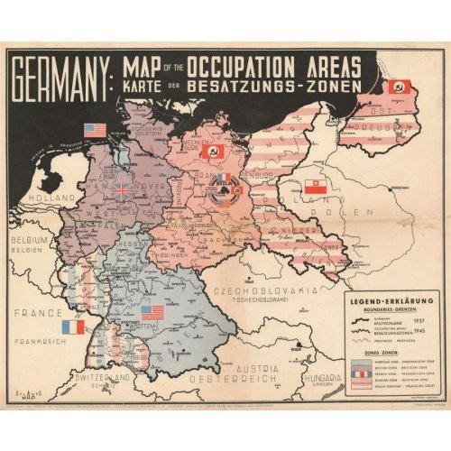
Original 1945 Atlanta GmbH Map of Germany | Post-WWII Allied Occupation Zones & Territorial Divisions Historical Cartography
Short SEO Description (Max 155 Characters)
Own a rare piece of post-WWII history with an original 1945 Atlanta GmbH Map of Germany. Showcasing Allied occupation zones and immediate postwar borders.
Long SEO Description
Product Overview and Introduction
Own a rare, highly significant cartographic artifact from the dawn of the Cold War with an Original 1945 Atlanta GmbH Map of Germany. Published immediately following the unconditional surrender of Nazi Germany and the conclusion of World War II in Europe, this vintage map captures the monumental geopolitical shift of a fractured nation divided among the victorious Allied powers.
Produced by Atlanta GmbH in 1945, this authentic period map meticulously outlines the four Allied occupation zones—American, British, French, and Soviet—along with the quadripartite joint administration of Berlin and the initial territorial changes that preceded the formal establishment of East and West Germany. Whether you are a dedicated historian of the 20th century, a Cold War researcher, or a collector of rare vintage ephemera, this original document provides a fascinating window into the reconfiguration of Europe.
Historical Significance and Postwar Geopolitics
As a primary source document from a critical turning point in global history, this map highlights key post-conflict realities:
-
Four-Power Occupation Zones: Clearly delineates the boundaries assigned to the United States, Great Britain, France, and the Soviet Union in the wake of the Third Reich’s collapse.
-
Post-War Border Shifts: Illustrates the immediate territorial adjustments and pre-Cold War divisions across Central Europe before the Iron Curtain fell.
-
Authentic 1945 Publication: Produced by Atlanta GmbH during the tumultuous closing months of 1945, capturing the exact geographical nomenclature and political divisions of the era.
-
Archival Collectibility: A genuine piece of historical paper ephemera that serves as an invaluable visual aid and display piece for museums, historians, and collectors.
The Ultimate Addition to Any WWII or Cold War Collection
When your historical collection demands authentic, period-accurate cartography documenting the division of Europe and the onset of the postwar era, the Original 1945 Atlanta GmbH Map of Germany stands out as an exceptional centerpiece.
Key Features and Benefits
-
Authentic 1945 Vintage: Printed in the immediate aftermath of World War II, offering true historical authenticity.
-
Geopolitical Rarity: Captures the delicate administrative phase of Germany before the formal 1949 split into the FRG and GDR.
-
Display Ready: An extraordinary framing piece for offices, studies, libraries, and historical exhibits.
-
Collector Heritage: Sourced from mid-20th-century European cartography, representing high-demand historical ephemera.
Specifications
-
Product Type: Original Vintage Historical Map / Cartography
-
Publisher: Atlanta GmbH
-
Year of Publication: 1945
-
Subject: Germany and Allied Occupation Zones Post-World War II
-
Language: German / European Cartographic Standard
-
Condition: Original Vintage (Normal aging consistent with 1945 paper goods)
-
Storage Recommendation: Store flat or framed away from direct sunlight in an archival-grade environment




















Reviews
There are no reviews yet.